Get the Big Picture with New Interactive Land Use Maps
Volusia County Economic Development
April 02, 2024
Have you ever driven by a vacant lot and wondered what could be built there? We’re often curious about land development because it shapes our day-to-day lives, neighborhood vitality, and economic prosperity.
In addition, businesses pursuing expansion or relocation and the economic practitioners assisting them benefit from mapping tools to address zoning and land use questions during the site selection process. When broad areas are being considered for potential building sites, accessible information like generalized countywide zoning and land use maps with parcel-level information become effective tools as location decisions are made.
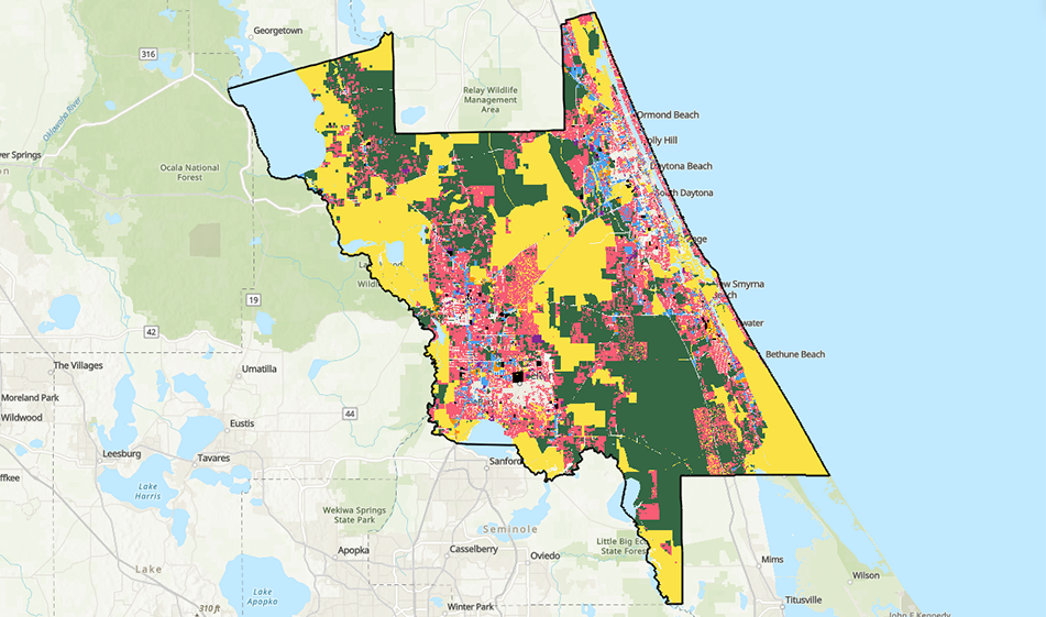
This is the reason Volusia County’s Economic Development and GIS divisions have developed new Land Use by Parcel and Countywide Zoning dashboards to provide a “big picture” view of a community’s current zoning and land use makeup. Now, whenever you’re curious about zoning or land use in an area, you have a go-to resource.
These mapping tools provide acreage and percent-of-total metrics for Volusia County and each of its municipal jurisdictions. The new dashboards allow users to quickly see how many acres are devoted to each land use type and what percentage of the jurisdiction’s total area each represents.
Would you like to know how much of your community is public land? Simply select your municipality via the jurisdiction filter and then choose “Public” via the Land Use filter located above the dashboard. These selections will show the acreage and percent of land area for the municipality and county. If you prefer a geographic visual representation of those selections, click the “Land Use Map” tab at the bottom. An interactive map will appear with a color-coded area representing your filter selection. Do you want to see land devoted to commercial use as well? Click the “Land Use Filter” above the map and select “Commercial” from the list. Both commercial and public areas will be shown.
There may be times when current and future land use will need to be understood to make the best policy or investment decision. When that’s the case, access the Countywide Zoning dashboard and select the jurisdiction and zoning filters that are relevant. Similar to the Land Use by Parcel dashboard, you will be shown the number of acres that are devoted to each zoning type and what percentage of the jurisdiction’s total area each represents.
These new land use and zoning dashboards are helpful tools that Volusia County residents and local policy makers can benefit from, and their value extends beyond the public to businesses and local economic development partners during the decision-making process.
